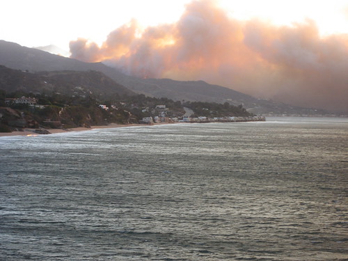
I canceled hiking this morning; they are advising Topanga residents to listen to radio and television throughout the day in case the fire department issues evacuation orders. I'm putting valuable papers in my car and getting ready to pack up the cats and computers. I was heading south on PCH, saw dozens of fire trucks with sirens on heading North on PCH towards Malibu.
At that time (9 AM), PCH was open at least North past Topanga, and Topanga Canyon was completely open.
I'll be posting updates as more information comes in on http://twitter.com/schof and here.
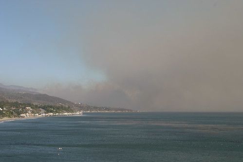
Update 10:39 AM: Fire is in the area around Pepperdine. I'm about 12.5 miles away from that by road; less as the bird (or fire) flies.
Update 10:45 AM: Malibu Castle completely engulfed in flame. Photos from fire on HereInMalibu's Flickr page.
Update 10:48 AM: Fire has crossed PCH; some homes along beach engulfed by fires sparked by embers; firefighters fighting to keep neighboring houses intact.
Update 10:49 AM: Update from HereInMalibu:
Our Lady of Malibu's school and Webster Elementary school now both in danger.
Three homes in flames on Malibu Road.
Fire crews at the Ralphs' shopping center, where palm trees are in flames.
Update 10:52 AM: Some brush on fire on Pepperdine campus; no structures involved on campus yet; students and staff evacuated to Cafeteria and Gym; not yet evacuated off-site. Malibu Presbyterian Church fully-engulfed. CVS Pharmacy on PCH on fire, but not engulfed. On news saw firefighters on roof.
Update 10:55 AM: From HereInMalibu
Update 10:57 AM: Inspector Ron Haralson from LA County Fire (interviewed on Channel 2) says 700 acres involved in fire; was 500 acres around 8:30 AM. Pepperdine students and Malibu residents evacuated to centers at Zuma Beach; Red Cross on site to provide assistance. No injuries reported. Three businesses; multiple residences destroyed.
We're listening to the scanner here in Paradise Cove. Now two fronts to the fire: east side of Malibu Canyon has burned through to PCH. West front still in the hills and now headed for the sea.
Fire in Serra Retreat. Spot fires in Civic Center.
Winds 50 mph. Gusts to 108 mph.
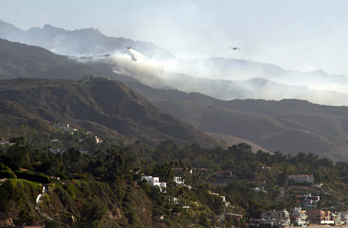
Copters sucking water from ponds at Pepperdine, which has been evaucated.
Update 11:01 AM: From Channel 2: 200 homes evacuated; five destroyed. Additional evacuation center at Agoura Hills High School.
Update 11:05 AM: From CBS2's Fire Fact Sheet:
ROAD CLOSURES
• Northbound Pacific Coast Highway at Topanga Canyon Road
• Southbound Pacific Coast Highway at Kanan-Dume Road
• Northbound Topanga Canyon Road at Pacific Coast Highway
• Northbound Kanan-Dume Road at Pacific Coast Highway
• Southbound Topanga Kanan-Dume at Mulholland
• Southbound Las Virgenes at MulhollandEVACUATIONS
• Residents in Puerco CanyonEVACUATION CENTER
An evacuation center is located near Pacific Coast Highway and Trancas.
Update 11:19 AM: From LA County Fire Dept:
Malibu Wildfire is at 0% containment now at 700+ acres. Several homes have been destroyed. Currently Evacuation Center is at Zuma Beach area, 200 homes have been evacuated.
Update 11:25 AM: Castaic fire getting larger; resources being diverted from Malibu to Castaic. At least three wildfires currently in LA County.
Update 11:29 AM: HereInMalibu still on-site; this is how close she is to the fire.
Fire now 750 acres.
No one - not even residents - now allowed through to Malibu.
Update 11:33 AM: From Pepperdine Website:
There is a fire in Malibu Canyon, near Pepperdine’s Malibu campus. At this time, as a precaution, all students have been relocated in Firestone Fieldhouse and faculty and staff residents have been relocated to Tyler Campus Center. Pepperdine has implemented its shelter in place plan. No campus evacuations are planned at this time.
All campus events have been canceled for today
Road Closures: Pacific Coast Hwy is closed between Topanga Canyon and Kanan-Dume Road. Malibu Canyon Road is closed at Mulholland Hwy.
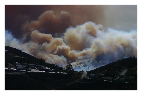
Update 11:40 AM: According to LA County Fire Department, fire now at 1000 acres, still 0% contained.
Update 11:55 AM: According to HereInMalibu, fire now at 1,200 acres. LA County Fire still says 1000.
Update 12:33 PM: Press Conference with Chief Micah Freeman of LA County Fire Dept. One thousand acres burned with zero containment. Aircraft are working the East flank of the fire because wind is driving the fire in SE direction parallel to PCH. No injuries to citizens or firefighters. Two commercial structures are a total loss; three residences are a total loss; 9 additional residences with moderate to minor damage. Four businesses at Colony Creek Shopping Center sustained damage. Fire is currently moving East towards Carbon Canyon area. Fire will last for days; thousands of homes will be threatened over course of fire. Voluntary evacuations: Coral Canyon, Carbon Canyon, Carbon Mesa, and Rambla Pacifica. Mandatory evacuations: Montenido, Malibu Colony, Puerco Canyon, Sweetwater Canyon. PCH is closed between Kanan Dune Road and Topanga Canyon; Topanga Canyon at PCH and Topanga Canyon at the valley side are closed to everyone but residents.
Update 12:58 PM: I created a Google Map of Mandatory and Voluntary evacuations based on the press conference above.
Update 1:19 PM: Photos from earlier in the day from HereInMalibu:
Update 1:27 PM: From emergency.pepperdine.edu:
The Malibu area is experiencing a significant brush fire under windy conditions. At this time, no pepperdine structures have been lost although the brush fire continues to burn around portions of campus. The L.A. County Fire Department is on hand with two strike teams and continues to monitor the situation carefully. Steps have been taken to shelter and place all faculty, staff, and students in the Tyler Campus Center, Firestone Fieldhouse, and Payson Library. Conditions can change rapidly, so all faculty, staff, and students are urged to stay in the three assigned locations and stay off campus roads.
All scheduled events on the Malibu campus for Sunday, October 21 have been canceled.
Malibu Canyon is closed from Mulholland to PCH and PCH is closed between Topanga and Kanan.
Update 1:47 PM: There's a site just created for Malibu Fire coverage: http://www.malibufires.org/ (Via HereInMalibu.)
Update 1:50 PM: MalibuFire.org's map of the fire:

I've also been updating my Google Map of fire progress and evacuations and road closures.
Update 1:54 PM: LA County Fire updated their status page:
Malibu Wildfire is at 0% containment now at 1000+ acres. Several homes have been destroyed. Currently Evacuation Center is at Zuma Beach area, Firestone Field House and Agoura High School.
Mandatory Evacuations:
- Montenedo
- Malibu Rd
- Malibu Colony
- Pepperdine
- Malibu Crest
- Serra Retreet
- Big Rock
Information on Animal Evacuations are:
Large Animals (818) 991-0071 Desoto/Victory
Small Cats/Dogs evacuation location is
Agoura Shelter
Update 2:00 PM: If LA County Fire Dept. info is correct, Big Rock Road is being mandatory evacuated. That leapfrogged some voluntary evacuation notices, and appears to signal a significant move or threatened move of the fire to the East.
Update 2:53 PM: More news from HereInMalibu's scanner:
Fire moving in both directions - just dropped to the hill above the Malibu Pier and is running uphill toward Saddle Peak.
800 firefighter now in Malibu. 1,000 more on the way. Firefighters' shift change has begun, with fresh companies relieving those who have been at work since before dawn.
Update 2:55 PM: LA County Fire says we're now at 1200+ acres; still zero containment.
Update 2:58 PM: Pepperdine says:
Students, faculty, and staff members who were relocated to the Tyler Campus Center, Payson Library, and Firestone Fieldhouse were allowed to return to their dorms and on-campus residences around 2 p.m. All are requested not to leave campus.
The Health and Counseling Centers have relocated to the Rho parking lot and will remain open until 9 p.m. for all members of the Pepperdine community in need of their services. Flashlights will distributed throughout the Pepperdine community due to cyclical power outages.
All classes on the Malibu campus have been cancelled tomorrow, Oct. 22. Only critical support personnel should report to campus tomorrow. The Pepperdine graduate campuses outside of Malibu will be open tomorrow and classes will be held. Only critical communication systems, such as email, Internet connectivity, and telephone services, will likely be available.
This matches what I've been hearing about the fires around Malibu Canyon being largely out, and the main thrust of the fire now being Eastward along PCH.
Update 3:05 PM: MalibuFires.org just cut-and-pasted my entire coverage onto their front page. It's all cool -- this is about getting the information out there, not monetizing clicks.
Update 3:17 PM: Cable went out, so no more TV. I'll try to stream something to get more reports. Verizon FIOS (obviously) still working.
Update 3:32 PM: Watching Channel 4 on streaming video now. I continue to update the Google Maps with new fire locations. Burning heavily on hills above PCH just West of Carbon Mesa road.
Update 3:35 PM: New photo from HereInMalibu:
Update 3:40 PM: Looks like the fire around Malibu Canyon is starting to burn again. So sez Channel 4.
Update 3:45 PM: MrPuffy has a bunch of photos from Saddle Peak Road looking down at the Malibu Fire. Channel 4 says 2000 acres burned; five residential structures destroyed; five commercial structures destroyed, and five residential structures damaged. Fire now appears to be moving West, says fire fighter interviewed.
Update 3:43 PM: News from HereInMalibu:
It's been quiet for half an hour now. Absolutely no wind, but we know that can't last. The fire burns south and east of us, zero percent contained, a hundred percent unpredictable.
Residents in the Cove are restless. We're caught between two traffic stops - Malibu Canyon and Kanan Road. Can't go south at all. North is iffy - you might get out, but chances of being allowed back in are slim. So we're stuck, waiting to see what the wind will do, where the fire will go. We walk to the bluff to watch smoke waft from the cleft in the hills and wonder what piece of our sweet home town we're losing now.
Update 3:53 PM: Updated Google Map; Voluntary Evacs changed to Mandatory. Got permission from MrPuffy to publish some shots:


UPDATE 4:01 PM: More from HereInMalibu:
And just like that, the fire heads west.
The wind kicked up again a few minutes ago, hot and strong and steady. Smoke pours out of Latigo Canyon, where planes and 'copters swarm. Almost 4 p.m.. We're heading into autumn dusk, an unsettling time to lose the light. Time to collect the dogs, pack the Plymouth and think about the best place to spend the night.
Update 4:14 PM: I see smoke North of me up Topanga Canyon. Not sure how that's possible unless wind direction has shifted. Just had a water-dropping helicopter fly over my house. Getting close to hauling ass.
Update 4:21: I think the smoke I see is from the Chatsworth fire, as weather.com shows the wind coming out of the NE -- which means it's NOT blowing the fire towards me.
Update 4:40 PM: Press Conference with Zev Yaroslavsky: Mandatory evacuation of lower part of Topanga Canyon, Lower Tuna Canyon area. People in Topanga Canyon are asked to take large animals to Pierce College immediately as a precaution. Sherrif Lee Baca: Evacuated Pepperdine, central Malibu, Rambla Pacifico, Las Flores, Carbon Canyon, Big Rock have all been evacuated. Tuna Canyon is being evacuated. Ocean side (near beach) of Topanga Canyon is being evacuated.
LA County Fire Chief: Fire has consumed more than 1200 acres; they have made considerable progress. Fire is being held in Carbon Mesa/Carbon Canyon area by air drops. No air drops will made after dark. Fire still not contained. Winds will double after dark. Approximately 700 firefighters are on site; 350 additional coming in overnight. 1500 people have been evacuated. Another couple of days at least until fire is contained. Malibu Canyon road between PCH and Piuma is closed until further notice. PCH is closed between Kanaan Dune and Topanga. 5 single-family dwellings and two commercial buildings destroyed. 9 single-family dwellings damaged; 5 businesses damaged. Topanga Elementary closed tomorrow; all schools in Malibu closed tomorrow.
Update: 5:02 PM: From LA County Fire Site: School Closures Tomorrow:
Malibu HS, Malibu Middle School, Point Dune Elementary, Webster Elementary, Cabrillo Elementary
Update: 5:05 PM: Deneill took some great photos of the fire:
Update 5:08 PM: Feeling uneasy, but not yet evacuating. Fire seems to be holding firm at Carbon Canyon / Carbon Mesa. This is good, except that winds are expected to pick up at night, and the helicopters can't drop water at night. They are performing mandatory evacuations in "Lower/Beach Side Topanga Canyon," but I don't really know how far that extends. I'm going to start loading up the car just in case, and getting the cat cages ready.
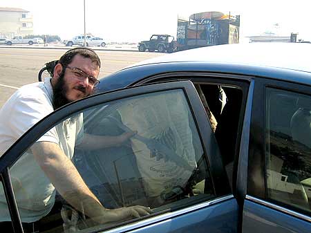
Update 5:43 PM: Chabad of Malibu evacuates their Torah:
Update 6:43 PM: Got the automated call asking me to evacuate. People South of Topanga Center should go south on Topanga to PCH, and then East on PCH to Pallisades High School. People North of Topanga Center (That's me!) should head North on Topanga to the Valley, and...I didn't really pay attention. I'm heading, cats-in-hand, to my parents house. Computer being shut down. Will update further tonight if possible.
NOTE: This is NOT a rush, panicked evacuation. We can't see flames, and it's probably just a precaution. Still, I said all along that when I got the voluntary evacuation notice, I would go. I'm going.
Update 10:07 AM, October 22: All additional news will be posted here, on an article for today's date: http://blog.sudosu.net/2007/malibu-fire-day-2-oct-22/